Friday 21 July 2017

​Day 4 and the end of the road! 17 July 2017 

We started this last morning of our GRR adventure with a delicious brekkie of Crepe Suzette a la camp (we eat very well on the road, always!) and arrived in Derby early afternoon. There we sat in a line of caravans for half an hour waiting to get a site! It's a popular destination.
You'll get it I'm sure! But yep we're at the end of the GRR.
I came across a couple of old tractors in the caravan park that had towed vans across 'The Road'. These stalwart travellers were from NSW and were returning there via the Tanami track. Us too!!

We made it! And what a wonderful experience it was. I can't help thinking how lucky we are to have been able to do it - and come through in one piece! The Kimberly must be one of the worlds last great wildernesses with its breathtaking beauty. I would have to say that driving the GRR must be one of the best ways to really appreciate its grandeur. The area is huge - Victoria and Tassie would fit into it yet its population is little more than that of Mildura. The gorges are gorgeous! The horizon is one of imposing rocky ranges in many places and in others a fringe of grey and white trunks with grey, blue, green crowns blot everything out except the ribbon of red ahead. It a land of strange trees like the boab and corky bark acacias - and often clouds of infiltrating red dust. It's a marine frontier visited by Macassans, Arabs, Chinese and Dutch traders and European explorers - but well after aborigines first came to these shores 50-60,000 years ago. It is a spectacular, ancient and 'surprising' part of Australia.
Next!? We still have a long way to go with many rivers to cross ........
Derby foreshore. Locals were fishing for supper. Incidentally the tides up here are 11-12 metres. Wow!

And as the sun sinks into the west ....... we will travel on to more wonderful places.

Day 3 on the GRR - a day of awesome mountains and gorges  16 July 2017 
Imintji roadhouse is run by the Imintji aboriginal community. It's a welcome site along this dusty road.

First a stop for fuel at Imintji just to be on the safe side. There had been gorges along the route, but we decided to wait till Bells Gorge. It was worth it! You access it via Silent Grove and indeed it was silent and shady with a couple of massive mango trees along side a small creek.
Yeah I know - not another creek crossing! We had a few on the road into Silent Grove.  And here it is 3 months into the dry season. Thank goodness there are no leaks in the car is all can say.
The track along Bells creek was lined with screw palms (spiral pandanus) and lots of trees and grasses and bright red dragonflies. We had water on side and the wall of the gorge on the other.

The creek track brought us out close to the waterfall. The rock was like pink granite and very slippery. No fences out here to stop people falling - they're a tough breed up here in the Kimberley!

Along Bells Creek to the waterfall, the smell of wattle and mint was delicious, but it was hot and thirsty work in the midday sun as the track in was a few Km. We wished we'd taken our bathers, but .... it was really worth it.

What a gorgeous pool! Far below me people were having a wonderful time. Had I been a little younger (aka fitter and braver), I'd have been down there, but it was a bit of a climb and a little bit slippery. I enjoyed watching!

I went as close to the edge as I dared to snap this. Awesome isn't it? They say its 150 m, but  it looked more to me from my high point and I'm sure it must have looked much bigger from below. In the background you can see small figures walking up to rocks; they were heading for the drop pool. They had to walk a ways up before descending to the pool.

The gorge sits within the King Leopold Range, named after the King of Belgium in the late 1800s. Composed of quartz sandstone and dolerite, it is just stunning, awesome and - gorgeous!
Totally impossible to capture the King Leopold Range with my iPhone but driving beside it was pretty spekky!

We hit patchy tar road about 100 or so Km out of Derby and stopped for the night by a dam. We slept with the smell of cattle and the squawk of black cockatoos. Our last night of the great outdoors - this time! Tomorrow we would reach the end of the GRR and arrive in Derby.
​Day 2 on the GRR - and loving it! 15 July 2017

This is the Gibb River. We crossed it to travel a little way along the Kalumburu road.
Around midday, we turned off the road and headed north to Kalumburu after talking to an older couple who were heading to Honeymoon beach for a second visit. I must point out that one of the traps in the outback is conflicting road condition reports. Like film reviews, it's all a matter of perspective, experience, expectation, and .... je ne sais quoi. Knowing this and despite very mixed reports, we still thought it was worth having a go. It was and wasn't!
Not a good omen! It's not our but .....

We got 6Km up the road and decided that it was way too rough given the return trip would be close to 600Km. So with the health of our valiant big beast and travel pod foremost in our minds, we did a U-turn and recrossed the Gibb River! back to the GRR.
This feisty beast was not happy with us coming too close to his patch. He looked like he was going to charge the van so we drove on.

We passed a big cattle muster west of Mt Barnett with helicopters, trucks, ringers and horses all part of the action which was fascinating to watch. There are a number of humongous cattle stations out here but the most you see are signs and occasional wandering cattle.
Not another water crossing!

It's very tranquil out here - once you stop bouncing around on the road!

Just trying to imagine what it must be like in the wet! We really must come back.

The road for most of its 600 odd Km is a series of creek and river crossings, watery and dry, interspersed with stretches of dips and gravel/rock. Many of the steeper sections of road over the many Jump-ups along the way are sealed which gave the ears and bones some relief. You don't realise how noisy it can be out there in the middle of nowhere, but you have to keep alert for possible problems. At one point I, the ears of this team, called a halt when I heard a noise which I thought may have been a tyre/wheel issue. Thankfully it just turned out to be a stone or bit of grit in the brakes. But it was lovely and reassuring to have another car stop and offer assistance (the driver was a former NRMA guy. Brilliant!). It was interesting to observe road etiquette, or the lack of it, along a road where travellers should be keeping an eye out for each other (you never know when you'll need a hand). We stopped many times, as you do to take in the view, and about 50% of the passing vehicles stopped or slowed to ask if we were ok which was most reassuring. But it was a little concerning that the rest just sped on past without checking this old couple by the side of the road! The law of the jungle I guess!
Steep parts of the road were sealed - how silent everything seemed on those stretches.

A dip? you don't say. The road was a series on dips .... and an endless raft of corrugations. Surprisingly there were a few road signs along the way.

We were delighted to see other caravans on the road - so many people had camped trailers.

We pulled up in another private gravel pit to assess our wounds, clean up any 'debris de tour', and enjoy another night under the stars.
We had a raging fire that night. It was comforting and suited our sense of romance.

​Day 1 on the Gibb River Road 14 July 2017
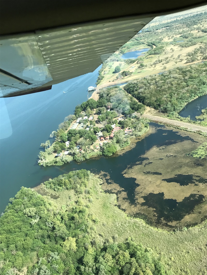
Right at the very beginning of this particular adventure. Yippee!

We hit the dirt 30 odd Ks after we turned off the Great Northern Hwy. And here we are - hooray! we made it to Derby in one piece.
Three days driving the GRR. 654Km (plus side trips) of mostly dirt, gravel, rock and corrugations. It's not for the faint hearted nor those concerned about getting totally covered in dust.

I prepared our pod for the long journey. I love duct tape! It saved a lot of food and avoided my nerves fraying

We had prepared as much as we could, had excellent Trek notes with GPS coordinates, distances etc etc, spares galore, a swag of manuals, rolls and rolls of gaffer and duct tape, heaps of food, fuel and water PLUS the essential ingredient - we really wanted to do it! We weren't alone. The GRR attracts people for many reasons - to feel the magic of the Kimberley, get a big taste of the outback, but always to meet the challenge of driving one of Australia's iconic outback roads. It really is the best way to experience the Kimberley.
One of the many crossings. One of the groups had a drone and were filming there crossing - many times! I posted a video of our trip across the river on my Facebook page. Check out the escarpment in the background. Awesome isn't it!?

There were lots of cars, camper trailers, caravans and even a couple of tractors pulling vans travelling in both directions. We also passed a few motor bikes and a couple of young cyclists going east. All power to them.
We came upon this gorgeous young man almost st the end of his tether. He and his mate are cycling around Australia. They had been riding 13 days on the GRR and he had just had enough. It was hot and the road was pretty rough. We stopped and chatted for a while to give him a bit of encouragement. He was a Melbourne boy and his mate was from the US. What an amazing journey they are on! And there we were tucked up in our comfortable aircon beast. All power to them!!

The people? Older people than us as well as many families with young kids plus tourists in rentals or on tours in 4WD buses. For all that, we were miraculously alone at night in hidey holes along the route.
That first day was exciting, but a time also to adjust the body, eyes and neck muscles! to rough travel. Lindsay did a simply amazing job driving. I was the navigator, the eyes and ears, the supplier of encouragement, food and drink!
Huge monoliths like sphinx were our guardians much of the way. Hard to capture the magnitude of the scenery we were driving through, it is just so huge. The colour of the road changed under our wheels as we drove from grey to white, red, yellow and brown.

We passed monumental ranges lined up like sphinx guarding the road and valleys. River and creek crossings too numerous to count, and dips and corrugations the entire way.
Oh no ... I feel a song coming on. Driving into the setting sun tra la la. .... A little while to go till dark but we were on a high after a fabulous and exciting day

We stopped for the night well before dusk, cleaned up the van and fridge, which was a bit of a mess with lids off a few things and a bit of spillage (yogurt coated lots of things .. ugh) but .... easily wiped up. AND THEN we popped the cork on a bottle of champers!
Champers? But of course. We sat out and counted the stars that night.

There we were slap bang in the middle of nowhere with nothing but the stars to watch us and the quiet mutterings of insects and birds to punctuate the magical silence - of the gravel pit!!
We were woken gently by the sun next morning with no time constraints on when we had to head off. Wonderful way to start the day! After stuffing ourselves with ham and eggs, we tied everything down and set off on our second day on the GRR.
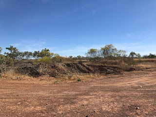
Our camp spot first night. One of many gravel pits along the road. We saw and heard no one! Utter bliss

​Lake Argyle 12 July 2017
Spill Creek - overflow water from the Lake. The rapids along this so called Creek are class 4 (out of a possible 5). They are raging and dangerous.

Lake Argyle - the meeting of big Waters. Our flight took us over Lake Argyle on the way to the Bungle Bungles and then back over the Argyle diamond mine. What a morning - then we came back for a late afternoon, dare I say sunset, cruise the next day!
Way down there is the Durak Homestead, one of the largest in Oz. The original Homestead was flooded when Lake Argyle was dammed. The old Homestead was shifted stone by stone and now sits close by the dam as a museum. The Duraks are famous in the area as pioneer settlers and explorers.
Just beginning the fly over Lake Argyle. It is like flying out to sea. And just 10k SE is the Tanami desert. The contrasts are mind boggling

Flooded valleys. Makes you want to ask what is an island and what is a sea.

A few stats you can skip over if you like, but for curious cats like me they were interesting. The Lake is 70k long NS and 55k wide on a diagonal line EW. I don't recall the volume but we're talking 30-50 times the volume of Sydney harbour (10000 GL sound right?). It's great volume means that the lake is classified as an inland sea. It's big! Levels peak in March and when flooded it covers 2000 sqK; a spill way releases 100,000L per sec WIW! That and the big dam control water levels. Talking of which the dam wall was started in late 1960s and now incorporates a hydro plant to generate electricity. Depth you ask ? Well it varies but between 15-40m.
This sort of sums up the lake. It's vast and awe inspiring. Puts a lot of things into perspective.

It provides a home, albeit seasonal, to 300 species of water birds and is classified as a Ramsay site. And boasts 20-30 species of fish, one of which (a catfish) is exported to Asia as silver cobbler! And 3 species of turtles. You'd be aghast to know that a group of people did a croc count and came up with 25,000 freshies but there are no salties that they know of. Good thing cos Lindsay and I went in swimming!
Talking of swimming, they host an international swim event each year. Nearly 300 entrants last year swim either 10 or 20k. Lindsay and I just bobbed with our noodles tucked under our arms and a glass of champagne in hand.
The site of alluvial diamond mine no longer operational. Diamonds were first discovered by geologist Maureen Muggeridge in the flood plains of a small creek. She traced them to the source near the current mine. There was lots of hush hush about the location as it was known in mining circles that they were searching for pay dirt. And the story goes that they set up a dummy mine base at El Questro to act as a decoy. Clever things.

The Argyle mine. No stats - sorry! But here is where some if the world's best pink and red as well as the rare blue diamonds are found. It's an area rich in minerals and beautiful rocks. On the south east side of the lake Zebra rock was and is still found. This stunningly striped rock and other beautiful silt stones were laid down around 700 million years ago.

​Bungle Bungles 11 July 2017
 
Your fearless adventurers buckled in and ready to take off! It was cosy but we both had perfect window seats. 

Our wheels and wings for a few hours.
The countryside we flew over on the way to the Bungle Bungles, was fascinating. Huge valleys dug out by rivers which barrel through the land during the wet. We want to do this again in the wet. It would be stunning!


The World Heritage Bungle Bungle Range looms up as oddly striped bee-hive domes, towers and other weird shapes and stretches across 450 sq k in the Purnululu National Park. The range is sandstone with an outer coating of a few millimetres in alternating bands of black showing the presence of cyanobacteria (which exist where there is a little moisture) and red/rust where the iron in the exposed sandstone has oxidised. The range and National Park lies 300 k from Kunanurra so we decided on a flying visit - literally! It was just the two of us with pilot and guide in a cosy little 6 seater Cessna.

These pix of the strange land forms speak for themselves. Zoom in the get a better look at the stripes and weird formations. Enjoy!

The views were awesome - deep narrow gorges, the domes and tower formations themselves as well intriguing landmarks such as the Piccaninny crater which is the eroded remains of former impact crater and named after nearby Piccaninny creek.


The National park, home to these awesome land formation, is also home to hundreds of plants and bird species. It's a very rich and diverse area only discovered by westerners in the 1980s.


We were airborne for well over 2 hours and enjoyed every minute of it - despite periods of gut-churning turbulence at low altitudes while we were flying over the range - of course! It was well worth it.
​Kununurra 7 - 13 July 2017

Some of the extensive cropping under irrigation. In the 'foreground' are mango trees and top left are Indian Sandalwood.
 Kununurra is an amazing place! I didn't know what to expect and was pleasantly surprised. It sits within an enormous irrigation region fed by the massive Ord River which was dammed in the 60s to control the flow of water and supply a growing agricultural industry.
The Ord River at Ivanhoe crossing. The crossing is still closed a few months into the dry season inspite of there being 2 dams upstream. Amazing volume of water.

Cotton cropping failed due to a number of factors as did sugar cane - except for the Kimberley specialty rum they make out of a small dedicated crop. Currently they are successfully growing a range of fruits, vegetables including a number of legumes, and chia the production of which is huge supplying much of the world. The big money spinner however is Indian Sandalwood mainly for its oil extracted for the pharmaceutical and cosmetic industries. It's a fragrant area. Diamond mining is still enormously productive including the spectacular pink.
And of course tourism is its other major industry and wow! was the place jumping. Lines of caravans queueing up every morning to get a spot in one of the 6-7 parks. And try to get a haircut - you had to book a week in advance, and they have 4-5 hairdressers!
Our caravan park by Lake Kununurra. More about the flight later.

We were camped beside Lake Kununurra so we took a sunset BBQ cruise of course! The lake is part of the Ord river which incidentally has hundreds of crocs of both kinds. They reckon 1 every 10m; we didn't count and didn't go in the water!

Specialty rum made with locally grown sugar cane.

Very special!!

Wyndham is only about 100k west of Kununurra so we scooted up there for a look at what is the oldest town in the Kimberley. It is located near the junction of 5 rivers which flow into the Cambridge Gulf. It was established as a meat export point for the burgeoning cattle industry back in the late 1800s.
Young boabs embracing! I just had to include these sweethearts photographed along the road to Wyndham. The number and variety in the size and shape of these strange trees is astonishing. And the age of some must be at least hundreds of years old.

The port of Wyndham beside the confluence of rivers.
This is a rock 'shop' where I spent a fascinating half hour or more learning about Zebra rock, a distinctive banded rock found in the East Kimberley near Lake Argyle. Outside there were huge chunks of rock, cutting machines and all kinds of rock mining paraphernalia. It was intriguing and I wished that we could have gone prospecting down by the lake.

Two special places near Kununurra are the Bungle Bungles and Lake Argyle but more of that later.
And as the sun slide into the lake, we headed back to camp after a BBQ cruise on Lake Kununurra.