Monday, 10 April 2017

The Ides of March! as we make our way slowly south east.
It's not all big days and bucket list stuff! Many days have been spent simply - going for drives into the hills, along rivers and streams, picking wild blackberries, fennel for our fish, and a new one for me, rose hips (they are still drying). New Norfolk along the Derwent is lovely. Lots of hops and other good things produced around there.
First night we were joined at Happy Hour by this little darling
We camped at Mt Field National Park for 3 days - it's a place we really love. Totally different to west coast and central highlands. Did lots of walks including 6 k on the Port Davey track in the footsteps of wombats and beside the mud holes and chimneys of burrowing crayfish, through peat and heathland and wooded hills careful not to tread on delicate fungi like babies ears. It's supposedly the hardest of the two tracks to Melaleuca; we did the easy first tiny bit of it.
The Port Davey track is not paved but in parts
boardwalk.s stretch  over marshy areas
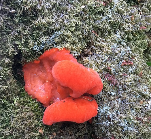
Entoloma chrysopus (I think - there are so many)
In spite of the consequences of damming and flooding (both negative and positive), Lake Pedder so beautiful. The Port Davey-Melaleuca track starts from the Scott's Peak dam at the southern aspect of the lake (80 odd Ks from Mt Field).
Lake Pedder, Australia's largest freshwater lake (Lake St Clair is our deepest),  is so beautiful
That whole area has a stillness and almost eerie tranqility. The towering craggy mountains that seem to engulf you, are awesome. We peered down the wall of the Gordon river dam - and couldn't see the bottom. It is a James Bond kind of place, the ultimate abseiling spot.
Needless to say we didn't walk out on the dam wall, but people do
Sheer madness!
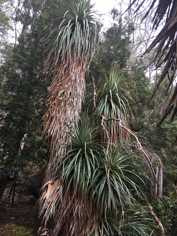
On Mt Field, we walked under towering eucalypts - the swamp gum/mountain ash is the tallest flowering tree in the world - amazing! We visited waterfalls dropping from high escarpments, and spent quite a few hours walking around Lake Dobson in Mt Field National park driving through alpine meadows to get there. Part of that walk is through a pandani grove (this giant grass tree is endemic to Tassie) interspersed with ancient pencil pine and pineapple grass. We saw many sub-alpine plants, even tasted a few of the mountain berries - snow berries, wild currants, pepper berries.
The worlds tallest flowering tree - Mountain Ash

Pandani - giant grass trees (we saw them also at Dove Lake,
Cradle Mountain but didn't know what they were.
We revisited the river which seems to start out of the rocks. It's part of the 30 km Junee karst system. The riverJunee bursts out of a dark cavern which is home to weird creatures - I could almost hear Tolkens gollum's evil hiss talking to his 'precious'. It is home to the endemic Hickman troglodyte a huge spider with feeds of cave crickets. I didn't see any - shudder! But it is a whole other world in those caves.
Then it was time to move on south ..............

Wednesday, 5 April 2017


Another magic day in the wilderness - albeit harder! Saturday 18 March

Cynthia Bay, south end of Lake St Clair
Woke to fog with no idea how the day would unfold weather-wise, but it was stunning - warm, not too warm, and with a 'strong breeze' which provided welcome relief during the day. Where were we? Lake St Clair, Australia's deepest freshwater lake, the headwaters of the mighty Derwent river, called Leewuleena 'Sleeping water' by the Tasmanian aboriginal people.
We set out to walk from Echo Point almost at the northern end of the lake to Cynthia Bay on the southern shore, a mere 10ks or 3-4 hours - they said!  Hmm .... of course it was longer than that at close to 12 Ks and it took us 6 hours (believe me every kilometre counts when you're not terribly fit!) - we walk slow, so much to ogle, but the 'path' was a tad more than the gentle undulations the Parks and wild life people promised. So with lots of ups and downs, scrambling over dense tangled tree roots and rocks and through sucking mud - we staggered into the visitors centre at 7pm totally 'bushed'. We'd left there on the ferry at noon!

Echo Point landing amongst the Leatherwood
Echo Point walkers hut
The ferry provides transport for people coming in from the Overland Track from Cradle mountain. Narcissus bay is where most finish the trek but some take an extra day and walk the rest of the way to Cynthia Bay stopping at the Echo Point walkers hut on the way. And that's where the ferry dropped us off.
We walked through rainforest with the usual suspects of Cheesewood, Stain wood, Sassafras, Celery Top pine and of course fragrant Leatherwood but here giant eucalypts joined the forest gallery and we walked by massive swamp gum/mountain ash. Ferns and bracken, colourful fungi (see below), tree ferns in frilly skirts, and fragrant patches of Leatherwood pumping out the delicious smell of honey - well that's what we reckoned! It was an every changing vista - almost.


Towering Swamp gum/Mountain Ash
Lindsay was my trailblazer! Clearing the path sometimes, setting the pace, helping me up and down 'nature's steps' that became increasingly hard (for me - but that's another story), handing me across streams and bogs - not that dramatic really particularly considering people walk a week on the Overland but ...... ... this is us!

Massive Man ferns - man bird watching in blue!
Boards and logs made some parts more passable
Only a couple of places we could actually get down to the edge of the lake but we walked with the constant sound of the slurping and slapping of waves breaking on the rocky shore which was littered right along with fallen giants.

Leatherwoods hanging low over
the last water crossing
It was a somewhat more challenging day than we expected but we're so glad we did it. It closed a bracket for us for the Overland track. Weeks ago we walked around Dove Lake which sits at the northern origin of the track near Cradle Mountain. Our days of attempting big challenging walks are well and truly gone but we can still dream a little by tackling the start and finish of them. We will be bracketing the great South Cape/Port Davey SW wilderness track before we leave Tassie or my name isn't .....? (we ended up only tackling the Port Davey end. A bit disappointing perhaps but you can't do everything!)


Pocking out of a fallen tree - Aurantiporus pulcherrimus (I think)

Ramaria - a coral fungus

​A magic day in the wilderness - Tuesday 14 March a day to remember!

Part of the rocky south coast
We are on our way to Melaleuca - finally
Bathurst Channel and Harbour together with Port Davey harbour in SW Tassie lies within the World Heritage Wildness of SouthWest National Park - over half a million hectares of pristine wilderness. The tanin-stained water of much of this huge waterway sits atop deep clear salt water, habitat to some unique marine species of fish, coral and invertebrates (I have included a pix of an info board which describes some of these). It's truly wonderful!

Flying into Melaleuca across Bathurst Channel
A place with unique water creatures
Off loading on a scrap of a crushed quartz airstrip in the
wilderness - very exciting!
That's where we escaped the here and now for one spectacular day. After hugging the coastline down through the D'entrecasteaux Channel and the rugged southern coast, our 2 small planes landed on a small crushed quartz airstrip at Melaleuca, a tiny dot in the wildness of the SW National Park. The only way to access this wilderness is to fly in as we did, come by sea or walk in along one of Tassies most challenging tracks either the Port Davey track from Lake Pedder or South Cape track from Cockle Creek. Both taking about a week each. There ain't no roads. You can see why we chose to fly!!
Perfect reflections 
Enough of the geography lesson.... after a long hike to a couple of long drops! we spent most of the day on the water looking rather like those clowns at side shows - heads swivelling back and forth with mouths wide open in wonder - spectacular, awesome, mind-blowing scenery, black still waters mirroring mountains and cliffs, trees and grasses. We came ashore on a secluded beach in Bathurst harbour for a delicious morning tea of Tassie cheeses and pate - yummy! How is it that coffee, well just about everything, tastes so delicious in the open air?!
What can I say!?

Warmed and ready for more, we piled back in the boats and were whisked off to the mouth of Port Davey harbour venturing a wee way into the Southern ocean just a tiny bit beyond the Breaksea Islands - rocky, grassy crags pockmarked with the burrows of short-tail shearwaters. The ocean was way too rough for our little boats but we were able to witness the relative protection the islands afford Port Davey Harbour against our wild magnificent Southern Ocean and the Roaring Forties that lash that part of the world.

The end of the Breaksea Islands
The Breaksea Islands from the air on our return flight
We hovered close to archways worn by the relentless sea flooding with each thundering wave, blow holes (embryonic arches perhaps) held us waiting expectantly for the next swell hoping to see the biggest and most spectacular explosion of freezing water yet, and we skirted rocky shelves awash with roiling froth and pouring water. Pretty wonderful stuff and our guide let us tarry for as long as possible.

A small pod of playful dolphins escorted us back almost to the Bathurst channel. They frolicked beside, behind and in front of our small boats as dolphins do. (Great video of the wilderness on Par Avion Facebook page - take a peak.) We passed the row boat 'moorings' where walkers from the Port Davey track make 3 crossings to get to Melaleuca - one to get across the Channel, then they tow a second boat back to the north side to leave it for the next people to use and then finally they row back across for the last leg of their trek to Melaleuca. Lot of hard work many days hard walking I'd say - but oh how I wish I were fit/young enough to do it!

My iPhone doesn't do justice to this stunningly beautiful place, but you get the idea.
With stomachs rumbling, we hightailed back to more tranquil water in Bathurst Harbour and ran the boats up on yet another secluded beach, Balmoral, for a delicious selection of salads etc washed down with oodles of good Tassie whites and reds. Life's tough!
Royally fed by our wonderful guides/pilots for the day, Luuk and Michael, we finishing up exploring Needwonnee Walk. This short bush walk along Bathurst Harbour gives a tiny snapshot of the life of the people who lived in this corner of Tasmania for 35,000 years; the track and interpretation boards were constructed by the descendants of those people - the Needwonnee poeple.

Our wee planes then headed north east across the rugged Arthur Ranges. Ducking behind Mt Wellington, we flew over Hobart sprawled along a silvery expanse of the Derwent river back to Cambridge.
Happy exhausted but happy travelers!
It was simply a wonder-filler day, a once in a lifetime 'bucket list' day. And a few days later we embarked on another such day - walking the last (easy!) leg of the mighty Overland track - Echo Point to Cynthia Bay. Awesome! More anon .....

Underwater wonders that live in the inky darkness of these waters 

Monday, 3 April 2017

Heading central and east - and it's still March!

Photo stop on the button grass plains not long since
ravaged by fire.  It is part of their history.
A long way from any apart water, burrowing crayfish build elaborate burrows
often with tall mud chimneys.  Their network tunnels can reach down many meters to tap into the water table.
Talk about extremes! In less than a week we travelled from high boggy button grass moorlands with their other-worldly mud chimneys built by the endangered burrowing crayfish to Erratics (remnants of ancient glaciers) and views of the cirques, amphitheatres high on the mountain ridge, that gave birth to those monstrous ice flows. And then on into the cool temperate rainforest of the Wild Rivers national park where we walked not much more than a Km along the famous Franklin almost tripping over delicate fungi albeit no as many as we found in our last visit when it was winter - sigh! Our destination Wayatinah in the central highlands on a lagoon and so peaceful. It makes a wonderful base to explore the huge network of lakes of the district including Lake St Clair but that's another story!
This is an Erratic - the rock not Lindsay!

Worth a read if you can make it out
Silence - what was I thinking?! We are sitting in a decreasing quiet as families arrive to set up for the long weekend around the lake - forgot that it was the long weekend .., oops! Mozzies the size of small birds land on my arms and challenge me to swat them. No power or running water to the site but its a lovely spot and there's loads of space. The sound of kids and birds echoes in the chill mountain air and the smell of fires and mozzie coils is reminiscent of childhood and camping.

Wayatinah Lagoon
We moved on towards the big smoke - Hobart but for a day or two we're in the 'bush', relatively speaking.


On the regular tourist trail!.
Jarring us back closer to here and now, we briefly visited the historic quaint chocolate-box village of Richmond with its 'old' bridge. The oldest post-settlement stone bridge in Australia.

The gap in the history trace from ancient natural history to the modern was a bit of a culture shock BUT tomorrow we hop on a wee plane and fly south to Melaleuca and the south-west wilderness. Hooray!
​The Tarkine in March

Ferns, fallen trees and bark meld together under blankets of moss and lichen
(and liverwort - but I didn't see any).
Over many days we crept through moss lined cloisters picking our ways through rainforest trees - leatherwoods, sassafras, horizontals, celery top pines, beech myrtles, dog wood and cheese wood, native laurel, Huon pines, towering brown top stringy bark, massive tree ferns, cutting grass and fungi - callooh callay! I spent much of the time either scanning the forest floor or down in my knees taking photos of bright scraps of colour poking out from dead tree trunks, delicate wee creaming mushroom-oids waving from under a fallen branch, dinner-plate sized leathery shelf fungi, squishy spongy ones, And more!
Russula mariae (I'm trying to learn some of their names but .....)
Maybe some species of crepidotus - anyone out there?

A coral fungus - but again I need the experts, please!! (I didn't pick it. it had been
kicked up by 'something' passing by)
I need a whole gallery (if I knew how) to show you the trees, flowers and fungi we discovered - with the help of my trusty EucaFlip, TreeFlip and FungiFlip often. How many hands does this woman have? Between walking stick, plant-info things and camera BUT we managed with NO mishaps. Oh and I forget the ancient moss and lichen - other-worldly shapes like plant creatures from Star Trek or shows like that. (I'd name these little beauties but I might get into more trouble than it's worth)
It was glorious but I think I like the forest in winter when the fungi come into their own.

And I almost forgot the deep mysterious flooded sink holes which dot Tasmania - karst topography which is caused by the dissolving of soluble rocks over eons to form caves, sinkholes/collapsed caves leaving massive stone arches in some cases and an underground river system (one such river we discovered spurting out from a rocky hillside in Mt Field National Park.

Trowutta Caves and Arch
You really need to be there to appreciate the amazing geological story of this fascinating Island!
​West Wilderness Railway - 9 March
We went to and beyond Hells Gates and lived to tell the tale! Seriously, we walked along Kelly's passage to the mouth of Macquarie harbour, Strahan. Looks innocent enough, but this treacherous entrance from the Southern ocean has claimed a few boats. Indeed this is a wild place but Macquarie harbour is a quiet and safe haven for $millions of sea going mega yachts - mind boggling.

The waterways and ocean of Strahan and the Macquarie harbour are mighty but we were here for something different - a trip into the wild hills sheltering the harbour on an ancient iron horse.
This old lady was made in Glasgow
Strahan to Queenstown and back - 10 hours up and over the mountains. It was a boy's own adventure day! An 80 year old stream engine pulled over 100 ton of wood and iron and people 40k and back. The smells and sounds were incredibly nostalgic - like many others on the trip, we got lots of videos to capture the sound of whistle and puffing of steam through the forest. It was wonderful. We passed ruins of some of the rail building camps and were told stories about the families of the rail builders who toughed it out in sometime appalling conditions. The kids were taken to school on the train; 2-3 hours there and back. Illness or injury well there wasn't a quick response from a trusty medical team!


Most of the line was hand cut through dense forest and rock. With a matter of inches at most in some spots between train and rock wall - wow! How they managed that in a relatively fragile environment with hand tools is mind boggling and the privations they suffered border on heroic.

King River gorge
The line hugs the edge of Macquarie harbour and King river until it gets to the river gorge and then the line goes up and over with a slope ratio of 1:15 wow! The train it basically wound up on a rack rail system. A mighty task taking 2 years to complete. It was a good day albeit long!

The indomitable Empire Hotel
At the turn around, we popped in to the historic Empire hotel for a massive typical pub lunch then it was 'all aboard' for the long trip home up and over the mountain again.


Sunday, 2 April 2017

Wild West Coast 1-4 March
Mouth of the wild Arthur River
 According to local signage and plaques, we're at the edge of the world!  Arthur River - on Tassies west coast and I reckon close to the most western point of Tassie (we did visit a place called West Point back up the road a bit which is probably closer to the mark but who's going to measure?!) The coast is wild and rugged albeit not with towering cliffs rather with huge skirts of jagged, rocky teeth and wild white breakers stretching way along the coast waiting to snare and chomp up unwary or unlucky boats.
The entrance to Arthur river looks pretty treacherous too and a local boatman told us that boats don't get in or out - but perhaps that's a slight exaggeration. The truth is that perilous entry has kept the Arthur River very protected.  The mouth of the river is littered along each side for great stretches by humongous tree trunks mostly washed down the river, out to sea and then thrown back by big seas high onto the rocks guarding the river entrance - we're talking 2 meter thick trunks.


We camped very quietly in an almost luxurious bush camp - no water BUT a flushing toilet! Whoa. We celebrated the relative isolation with champers and King Island cheese prior to lighting a camp fire so we can sit around sing cum by ya!! Surrounded by smouldering mozzies coils of course. Life is ok! Tasmanian Parks and Wildlife carve out and maintain camping spots like this all over Tassie and do an wonderful job keeping special places accessible, where appropriate, and they are always ready with lots of information including local delights not mentioned in guides.

This little boat 'Reflections' was skippered by a knowledgeable local  Great day!
During our stay there we took a small boat cruise deep into the Tarkine stopping at the junction with the Franklin for lunch which included lots of Tassie wine - funny about that! We saw white bellied sea eagles, wedgies, huge eels and a spotted quoll.  It was a tranquil day.

Balfour adit - it's fenced off but I stuck my trusty phone through the bars.
Arthur River was a marvellous spot to use as a base and go exploring. And we did over many (showerless!) days - ah the beauties of bush camps! We have the capacity to carry over 200 litres of water, but showers seem a bit of a waste when you want an extended stay and we were going on to another place without water. We made do with a good ol' bucket - conjure up images hmmm!?
And so we enjoyed the Tarkine and a past ancient and relatively new.
Deep in the heart of the forests of the Tarkine are the remnants of a rich mining past - gold, alluvial tin, copper and iron pyrites. One day we took a less traveled 'road' off the gravel road between Arthur River and Corinna to try to locate the old mining settlement of Balfour. It was not a road for the faint-hearted! Deep in the hills and forests along side coral ferns, delicate flowers like mini dog roses, pink trigger orchids and mini wild currants showing just a blush of pink, we found the tailings and mulloch heaps of Balfour mining, which closed around the time of WWI.

Mirror surface of the Pieman River disturbed
 a by our ripples as we glided downstream.
It was a day of exploring the past from early mining to ancient middens and aboriginal petroglyphs dotted right along the west coast. This is an ancient and fascinating coast!
One can't take the Western Explorer, the gravel road between Arthur River and Corinna without a boat trip downstream to the mouth of the Pieman River and of course a walk on the Huon trail and upstream along the Pieman and through the rainforest. Just goes without saying that we walked where we could - skirting round a large tiger snake taking the late afternoon sun - we looked but kept our distance!


I turned over a rock on the beach and fond this
tiny green spider - who would have imagined

the wide sandy mouth of the Pieman. Just to the left of the pix the
beach is strewn with huge logs washed down the river.